The trip to Alsever Lake
I didn't sleep well as I'm still not used to my hammock. I was given one by my girlfriend as an Xmas gift and used it exclusively for a 15 day trip the month before and still I was not having any decent sleeps in it. I'm not sure I'll ever get used to it.
I woke up at 2:36am & went for a pee (Does beer make you pee more?). All was silent and the forest glowed as a fuzzy moon overhead bathed the campsite in an opalescent light. Pretty… I went back to sleep or rather some semblance of sleep.
Woke up at 6:00am. I tried to sleep-in but was restless and by 6:50am was up and out of the hammock. At 7:00am my wristwatch alarm went off. I really didn't need it (The wristwatch), but I figure if I wanted to stick to my itinerary, a little electronic self-motivation doesn't hurt; Time to get going - I had a long day ahead of me.
While making coffee and my humble breakfast of oatmeal, a hummingbird flew into the campsite, examining various flora. I received an additional two visits from the hummingbird as I ate my breakfast. The bird and I had something in common; food.
A red squirrel was out and about, but he kept his distance. The loons were on the lake calling occasionally. Their haunting song echoing across the still water as the sun rose to colour the world. It was a really nice morning, one that makes me wish time could stand still… So that I could enjoy its beauty at that moment, forever.
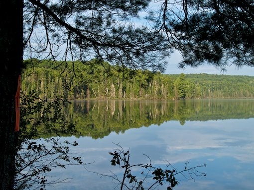
I packed up and departed the campsite at 8:45am under a now mostly cloudy sky. I really liked this lake and wished I had decided to stay an extra night so as to explore her. The water clarity and the shape of the lake offered lots of possibilities.
I passed a familiar rock outcropping on the lake as I paddled over to a campsite that a few friends of mine and I had decided to visit on a day-trip that we had snowshoed to, two winters previous while winter camping on Wilkins Lake. We had decided at the time it wasn't much of a campsite and here in the present in a canoe I couldn't have agreed more, I didn't even get out of the canoe. I had definitely picked the best site on the lake to camp on the night before.


I arrived at the first portage of the day at 9:10am, the sign stating that the trail distance being 695m. What the sign didn't indicate but I already knew was that the portage was uphill all the way to the next lake, that being Breezy Lake.
I geared up for the single carry and headed up the trail. The way was not easy as after a few meters I came across a patch of moose muck and grass that was a mess to cross, but once this was overcome, the trail began to ascend onto more solid ground, the rest of the carry being a relentless uphill carry. Twenty minutes later I arrived thankfully at Breezy Lake. I was beginning to appreciate single carry more and more… I didn't have to go back and do it all over again!
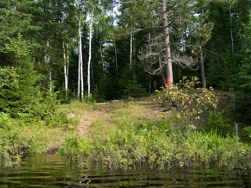
I took a short rest then paddled onto Breezy Lake. It is a small lake with one small campsite that I reached in less then 5 minutes. The campsite was empty and I paddled onwards reaching the rocky take-out to the next portage at 9:55am.
I took a few minutes after preparing for the carry-over trying to photograph cray-fish that polluted the water at the landing. The water was heavily reflected and the photos didn't turn out too well. There was a multitude of brightly orange coloured crayfish there. Many were alive and some were dead as well. I couldn't believe the numbers. Pretty.


The portage to Wilkins Lake being a long one was indicated by the signage as being 1,475m, but had been GPS'd as being 1,720m. All I knew was that the trail was a long rough one that seemed to have a never-ending shallow climb to it. I geared up for the single carry and didn't get very far, perhaps 300m before I put the canoe down. The trail was climbing ever so slightly with a slope off to the side, this coupled with a rough footpath over roots and moss covered rocks made for a jarring trek. It was taking a toll on me so I put the canoe down and carried on.
Eventually, I reached an old logging road that I was familiar with. There is something that should be noted about the road crossing: Continuing on towards Wilkins Lake one has to turn right and walk about 20 meters or more (Away from the direction of Wilkins), before finding the continuation of the portage which in turn heads towards Wilkins Lake.
The lack of signage indicating the direction one has to travel to find the continuation of the portage might cause confusion. To keep it simple, just remember this: No matter which way you are going, one has to jog to their right about 20 meters along the road before finding the trail again and re-entering the forest. It feels opposite to what one would normally find when crossing that road, but just remember the 20 meter jog to the right and you'll be fine.


About 100m or so up the continuation of the trail, I put my pack down next to a tree that was marked with paint indicating that there was an underground bee nest. I headed back and grabbed the canoe. Upon returning with the canoe, I had to spray bug repellent all over me as the mosquitos were becoming bothersome on the trail. Subsequently, I noticed an increase in humidity levels as well.
I geared up and single carried for about another 400m before dropping the canoe. The rough trail again sapping my strength. The trail had begun to climb more and had become more rocky. Though not possible to see in the overhead tree canopy, there is a high rocky ridge to the North of the trail. I saw this before during a winter trip through the area. Now all I could see was trees above me and the buzz of insects in my ear.
The trail finally started to descend through what felt like a dry river bed… So rocky it was. There seems to be a spring that crosses the trail about 20m before I arrived at the put-in to Wilkins Lake. The water crosses through a grassy area on the trail, bubbling through rocks and a stand of thick bush to the north of the trail. If one could find its source nearby, it might be possible to secure a fresh water supply there, if indeed it were a spring. I believe it could be.
I heard voices as I approached the take-out, I called out a "Hello" warning seconds before my arrival. I entered the far side of a campsite as I approached the water's edge. Two guys were camped there. I was about to put my gear down when I was told that I had passed the put-in. I had been here before and knew where the put-in used to be, respecting their wishes I back-tracked. Sure enough an unmarked rocky landing was there. Making my way down onto the rocks I deposited my pack and turned around to head back to chat briefly with the two guys. It was then I noticed the portage sign facing the lake. I'm guessing it had been moved for it used to be right on the campsite.
The two fellows were locals from Barry's Bay and they mentioned their surprise at seeing me come down onto Wilkins Lake from the direction I had come. No one ever came that way they said. Wilkins Lake was visited mostly by locals like themselves, usually coming up the cart trail, which I had done once before during a solo visit to Wilkins Lake in the autumn of one year. I mentioned I had to return for my canoe and they did a double-take as they realized that I was solo. For all the soloists I have seen in Algonquin Park, I get the feeling that it is still seen as a rare thing among the general population.
We wished each other well and I headed back up the trail to retrieve the canoe. The return trip was uneventful and I was loving the canoe….Ohhh so light she was! I put-in into the water at 11:30am paddling onto a very calm and beautiful Wilkins Lake. 1.5 hrs to cross that trail, lousy time but hey I was here to have fun, not break any portage speed records.
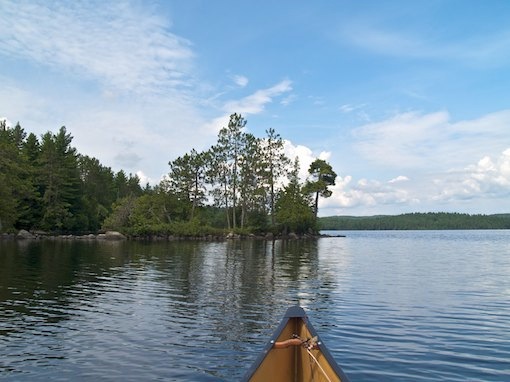
A pang of regret touched my mind as I paddled along Wilkins Lake south shore; I should've booked a night on this lake. It was a big lake and could get really windy, but there was something about this lake that held me in thrall. Maybe it was the remoteness of the lake?
Large cumulus clouds began building as they drifted over the lake, a slight haze in the atmosphere began to show as the humidity increased. I paddled on, visible in the distance was the rock slope where I had camped many years earlier during an October visit. At one point I stopped and filtered two litres of water, knowing I had several portages ahead of me still.
As I approached the bay (Where the portage was located) at the Southwest corner of the lake, I spied a familiar landmark along the shoreline and paddled towards it. I pulled up and landed along the West shoreline, making my way inland I trekked up a hill and at 12:00pm arrived at the location of my winter camp a few years earlier. It was quite different to see the location in summer. Most of the woodpile we had left behind had disappeared, probably by some summer camper foraging for firewood. I took a photo of the location and headed back to the canoe.


By 12:15pm I arrived at the 970m portage to the Aylen River. I double-carried the gear up the small hill that was at the beginning of the trail. I had some gorp and water then headed down the trail single-carrying, it was 12:25pm. For this portage I was going the correct way for the trail had a downward trend through a small rocky ravine. After about 300m I put the canoe down and carried on... It was too rocky for me to carry the heavy load single-carry. Still it is a beautiful area to walk through. The trail did eventually level off to an undulating pace. Just before I arrived at the end of the trail, the portage crossed an old logging road... So you know you are getting close when you come across that road.
I arrived at the end of the trail, dumped my pack and did the return run for my canoe. I finally arrived with everything at the Aylen River just after 1:00pm and decided to it was time to eat. Lunch consisted of tuna (From foil) in a tortilla wrap with cheddar cheese and mayo. I had two of these and washed it down with water. I also had a pepperette stick and some gorp.


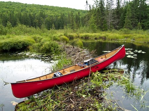
The put-in was tricky… Balancing on two unstable logs as the canoe sat on a bed of mostly mud. I would not want to fall in there. Finally, I dragged the canoe out far enough so that I could leap into the canoe and sit down, all in one motion and pushed off and got as far as two feet. It was now 1:30pm.
I was on the water or more correctly I was standing in the river bottom, as I got out and began dragging the canoe through very little water and sand. I was in brand new territory now, having never been on the river before, thus the excitement built-up inside me. I did a U-turn around some logs as I joined the river proper and came upon my first beaver dam.
Crossing this I put-in into some deeper water, but it had some rock here and there with the water being barely deep enough to paddle over most of the rocks. I could see another beaver dam ahead of me about 100m upstream. This second dam had lots of fresh cuttings on it with some running water passing though it. This second dam did the trick, raising the river level by almost two feet.

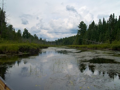
Two minutes later and yet another dam the river took a left turn and that is where I was able to finally relax; The water depth increased, though the river was clogged somewhat with vegetation. Still, with almost no current to speak of - paddling through the deeper water, I was able to navigate with little trouble. It was overcast now with humidity levels increasing.
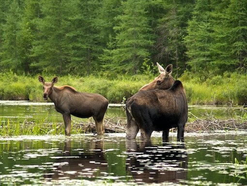
By 2pm I could see a shape ahead as I came around a bend. It was a moose, a cow moose at that, standing in front of a beaver dam. The moose was feeding on the plant matter in the river in front of the dam. I paddled up quietly as I could slowing my pace, my arms moving with a slow-motion mechanical rhythm. Paddling up the shoreline on my left, I was watching the moose when an odd thing happened; The moose became a two-headed moose!
As I moved closer I could now see that it was in fact a second moose, a calf. I slowed down and pulled up to within roughly 4 canoe lengths. The calf separated from its mother and began to feed closer to the dam. The mother continued to feed as it kept watch, looking at me occasionally.

I spent a glorious ten minutes slowly photographing the pair as they fed. Not only was I in heaven but I had front row seats too! I crept up closer and closer to within three canoe lengths. Suddenly, the cow moose snapped her head around as she stared directly at me across her back. I froze, my insides chilling instantly as my eyes darted here and there along the shoreline, looking for a sturdy foothold for a quick escape.
The moose continued to stare at me for a full two minutes. I began to shudder as fear seeped through me, the cold inside me spreading like a plague… I was very scared, I had crossed the line, I had paddled too close to the moose and her calf. The good news was that the cow moose had not yet charged me and was unlikely to do so if I continued to stay right where I was. Finally, after what seemed like hours, the calf moved to stand upon the dam, as it continued to feed. The mother moose moved as well, paralleling the calf along the dam as the pair made their way to the opposite shoreline, with the mother now raising her muzzle to sniff the air.
By 2:15pm it was all over, the moose moved into the bush and disappeared, I headed for the dam, pulled the canoe over and launched onto an ever-widening river. Fifteen minutes later I came to another dam that was quite large with fresh cuttings piled on it… The dam was holding back well over two feet of water in height. It was after that dam that I leaned back and really began to enjoy the river, it was wide with less vegetation clogging the water and wide sweeping turns, I scanned the surrounding forest as it drifted away, giving way to boggy terrain. My speed increasing as I made progress through the widening river.

By 2:45pm it began to rain, I tossed on my raincoat and paddled onwards, the rain becoming a torrential downpour. This went on for at least ten minutes when I spotted through the heavy rain a glimmer of yellow. It was actually easy to see, as there was some thin forest along the shoreline, just the heavy rain was making it difficult to see. For the last kilometre along the North shore, I had noticed an increasing presence of ferns along the shoreline as the forest was thinning out.
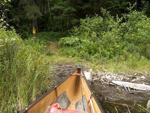
I paddled up to the take-out which was a short narrow channel leading to an easy flat grassy pathway. The river beyond went through a large bog and twisted out of sight. The continuing river did indeed look inviting to paddle, but not on this day. I had two more portages to go, it was still raining (Though not as hard anymore) and it was 3pm, time to get moving.
Looking at the map and the trail before me I could tell that I had a climb ahead of me. I was growing fatigued; I had been going since before 9am, six hours now and I had at least two more hours to go I figured. So I headed up the trail with my pack, camera bag, cooler bag and paddles. The trail became turbulent with rocks, roots and mud, then shortly climbed up a steep hill for about 10 meters before the grade became shallow, but the climbing continued. The trail itself was now perfect underfoot; becoming compacted hardened earth with a well worn track.
It was still raining and for most of the length of the trail I walked through a forest of ferns instead of trees. At one point I left the trail to wade through the ferns to get a closer look at a tree stump. The stump was burnt. A forest fire? The more closely I looked around me, the more I began to notice tree stump after tree stump, crispy and blackened. Then along came standing tree trunks, charred like twigs. The whole area had suffered a burn-over from a forest fire. Now ferns were taking over and in a few areas, stands of poplar and birch were growing in fast.


I completed the 780m carry and trudged back down to retrieve the canoe. By the time I reached the canoe, the rain had stopped and I practically zoomed up the trail with the 'light-as-a-feather' canoe on my shoulders. I was really enjoying this trail, this canoe. 3:56pm and I launched onto an icky looking pond. The body of water had no name and rightly so. The water was very cloudy and disgusting looking. The muddy bottom served as guide for me to slide the canoe up to the take-out as I left the pond at 4:05pm... Yeah, it didn't take long to paddle that pond and I didn't linger either.
The last portage of the day, 670m. Not as much climbing and some dips and a downward trend for about the last quarter of the trail. Again there were ferns but not as much as there was much more forest. At one point I passed by a heavily wooded stand that was dark from the canopy above, the trail skirting its parameter as it snaked on a downward course towards Alsever Lake. I arrived with the pack and other gear at 4:26pm and immediately turned around and headed back for the canoe. I was excited… The Lake was like glass and soon I'd be making camp for two nights.

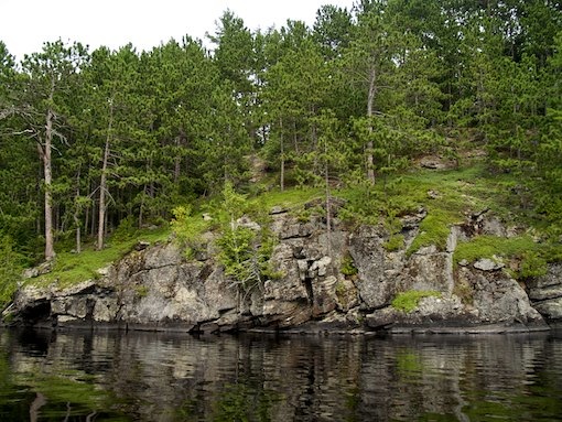
The return trip was uneventful, the trail same as the one before… Hard-packed earth, with additional dips and climbs through-out, overall an easy trail. I arrived back at Alsever Lake, loaded up and launched onto a dark glass-like surface at 5:05pm. Paddling a bay before the lake opened up proper, I noticed a rather high hill off to my right, at the top - the hill had rock cliff towering above the land below. It was less than a kilometre away and I admired the landscape as I paddled on.
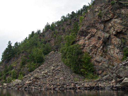
Emerging onto the expanse of Alsever Lake, I decided to paddle the Northeast shore as the majority of the campsites on the lake resided there. It seemed to be the safe bet and in this decision I was wrong but in another respect it was the correct choice; As I paddled up the shoreline a massive cliff face came into view, beyond it a large rockslide and yet more cliffs. I had no idea there were cliffs on this lake. As I paddled by, craning my neck in astonishment at the beauty of the cliffs, the sun popped out for a few moments almost as if it were showing off nature's pride and joy of Alsever Lake. It is at times like this that Algonquin Park makes me believe in magic. I was in awe.

By 5:35pm I had passed the cliffs and continued on, looking from a distance at the first of four campsites along the shore. I was too far away from the first campsite but it looked bushy, the second was loaded with red pine and fairly level. It also had a lattice work of pine or spruce poles for putting up tarps. This was a fishermen's camp. I paddled on… I only had one small tarp and I didn't like the idea of that naked lattice there in my view.
The next site was on a slope but was open to the lake. I also realized that the lake was tea-stained… The water had a very red colour to it. The next site (The fourth) could not be found. I did find a spot that looked to have once been a campsite, but the fire-pit was scattered and there was no sign. I figure the campsite had either been closed or the sign had succumbed to the elements and the site had slowly been abandoned.


With the lake still calm but with threatening clouds hanging in the air I made my move to the West across open water, to a peninsula on the lake that had two campsites marked on a map. I paddled over to the campsite on the far side. It was very rocky with lots of pine and with a fire-pit open to the lake. I immediately liked what I saw. The site was very rugged and wild looking. There was no landing and so I had to get wet, unloading the canoe from the water onto the rocks above me. Once all my gear was on the rocks, I carried the canoe into camp and overturned the craft lodging it in-between some trees. It was 6:10pm.
I had a pretty good view, where the sun would set and I could also see in the distance the marshy narrows through which Roundbush Lake drained into Alsever Lake. I could not see the cliffs from my campsite. They were viewable only from the other side of the peninsula, behind my camp.

As I began to set-up my hammock, thunder could be heard to the south of me. I cleaned out the fire-pit, which had some traces of unburned garbage and a broken fishing-rod. Collected a modest supply of fire-wood and got a fire going. My meal was simple; Sausages with cheese on a bun. I sat down to enjoy my meal, finding a sweet spot among the rock that fit comfortable like a stone chair, below me was the fire-pit and the lake beyond. The view was coloured by the setting sun as it peeked through broken cloud cover. As I ate my dinner I noticed more clouds moving in from the South, clearly weather was headed my way.

By 9pm I couldn't stand the onslaught of mosquitos anymore and decided to head to bed. I hung my food, covered up my firewood with the lone spare tarp I had brought along and put my pack away under a cedar tree. Everything was prepared for rain.
By 9:15pm it began to rain and that's when I finally crawled into the hammock. I struggled and struggled for what seemed like an eternity to get comfortable in the hammock. After about 20 minutes of this, I suddenly found a sweet spot. It felt so good that I immediately started to doze off to the rhythm of the falling rain, perfect!

At 10pm I was awoken by something undefinable. It was still raining steadily and through the sound of the rain, I became aware of another sound. I say 'aware' because I could feel the sound more then hear it. As the minutes passed the intensity of the sound increased. I was seriously beginning to think I was imagining it when the rain began to subside. It was then that I could clearly feel and hear the sound of a high-powered car stereo. Obviously, some local knew the logging roads into the backcountry and was out for a Saturday night party.
The bass of the music throbbed through my body, though the music was distant and faint, the bass felt very uncomfortable, there was no escaping it. "There ought to be a law", I thought. Too much bass isn't a good thing, I thought to myself. Getting up and walking around didn't do me any good (I was getting soaked) so I returned to the hammock and for the next horrible two hours I had to lay there and put up with it.
Though difficult to locate, the noise appeared to be coming from the general direction of the Southwest corner of the lake. The sound oscillated a lot as it was obvious the vehicle was travelling through the forest while blasting music.
This to me was the worst noise transgression I could ever hope to not experience in Algonquin Park, as I have a sensitivity to low frequency harmonics, it makes my heart race. I purposely goto Algonquin Park to escape such noise pollution and now was being saturated in the very same noise I was trying to escape. This clashed terribly with the environment I was accustomed to in Algonquin Park. I was very, very angry.

Finally, after midnight the noise ceased and I fell into a light sleep from which I awakened often as the overnight temperature seemed to rise, along with the humidity levels making for a damp, sticky sleep.
Previous Page - Day 1 | Return to Top of Page | Next Page - Day 3