Downloads
This page has a selection of free stuff that you can download for your own personal use. Some downloads such as maps are third-party creations. While others, such as wallpapers and videos are of Mark's own creation. Use the menu below to navigate to the download sections of your choice.
Enter the name for this tabbed section: Audio
An Algonquin Christmas
Written & narrated by Mark Rubino, Produced by Sean Michael Paddison
A few years back, I was asked to write a poem about Algonquin Park for a Christmas album. At the time I had only been to Algonquin once during the Christmas season. The memories were still fresh in my mind, as my trip had occurred only 6 months previously. Although Christmas is a human tradition, it is still an exciting time to visit Algonquin Park. Winter has it's own unique beauty, something that everyone who loves The Park, should experience at least once in their lives. Below is a download link to an mp3 file.
File size - 1.1MB
Enter the name for this tabbed section: Jeff's Algonquin Park Maps
Born out of necessity - A desire that was fed by the need for a more accurate map while paddling Algonquin Park's interior, Jeff laboured for four years and released his own version of the canoe routes map of Algonquin Park in 2008.
Since then, Jeff’s map has gone through several revisions & improvements. Nowadays, Jeff’s map(s) are a popular alternative throughout the paddling community. Jeff has also expanded his mapping business to include other parks such as Killarney and Temagami. The information and amount of detail in the maps is astounding.
Below are downloads (Mirrored with permission from Jeff) of all five versions of Jeff’s Algonquin Maps. Click the buttons below to select any version of Jeff’s Algonquin Park maps.

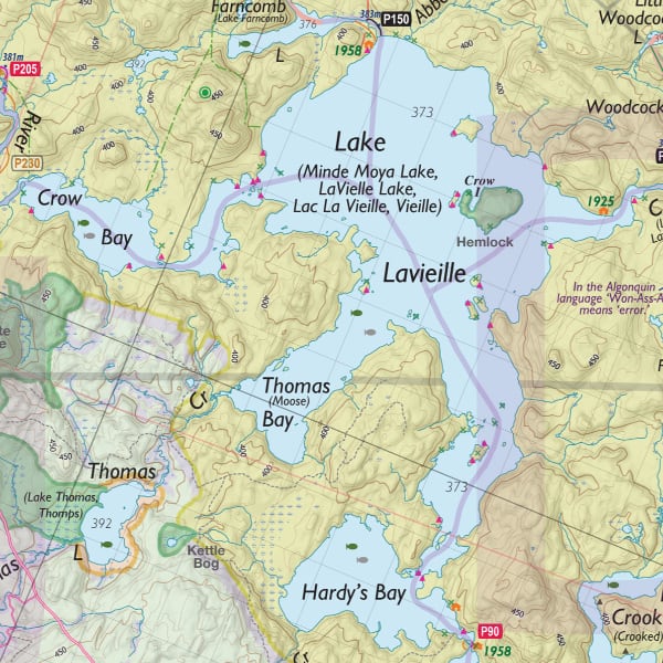
In 2008, Jeffrey McMurtrie released version 1 of his Algonquin Map. The inclusion of campsite & portage GPS data was a major highlight of the map.
For the first time (On any publicly available canoe routes map) primary logging roads were displayed. Such data usually evokes scorn from a canoeist's perspective. I found the data useful - When used in combination with the AFA Harvesting schedule map I was able to plan my canoe trips away from the noise associated with logging operations.
For the first time (On any publicly available canoe routes map) primary logging roads were displayed. Such data usually evokes scorn from a canoeist's perspective. I found the data useful - When used in combination with the AFA Harvesting schedule map I was able to plan my canoe trips away from the noise associated with logging operations.
File size - 50MB
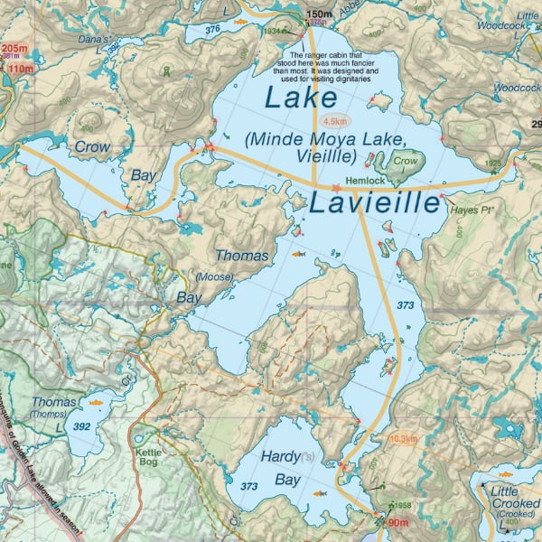
In March of 2009, Jeff released version 2 of his map. Among the improvements were more organized legends, the addition of contour lines, fishing information and some changes to additional map icons.
Historical information continued to be expanded as Jeff began to include more and more facts related to history within Algonquin Park, a nice inclusion to the map.
Historical information continued to be expanded as Jeff began to include more and more facts related to history within Algonquin Park, a nice inclusion to the map.
File size - 128MB
In November of 2010 Jeff released version 3 of his Algonquin Map. The map continued to evolve with Jeff including dozens of hiking trails in the legend. Not just in Algonquin Park but surrounding areas as well; The map no longer catered to just canoeists, but those of the hiking community as well. The map was truly becoming as diverse as The Park itself.
File size - 118MB
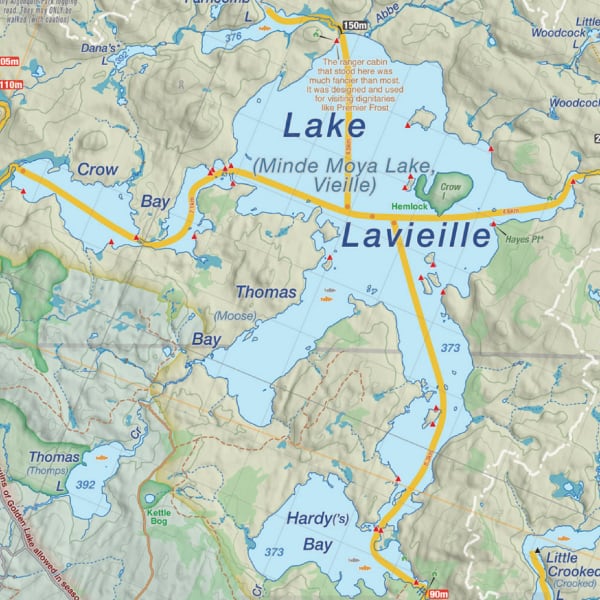
In the spring of 2012, Jeff released the much anticipated version 4 of his Algonquin Map. Enhanced relief shading and an improved colour scheme were among the updates. Jeff’s map continued to make gains in quality. Additional paddling areas such as the Frost centre and the Poker Lakes region were added to the map. A welcome addition!
Removed campsites were omitted from the new release. I think this was the right decision; Would-be explorers could impact a closed campsite’s ability to regenerate.
Removed campsites were omitted from the new release. I think this was the right decision; Would-be explorers could impact a closed campsite’s ability to regenerate.
File size - 96MB

Version 5 of Jeff’s Algonquin Map is the latest version (And last version) of his map under the Jeff’s Algonquin Map brand. The physical map sells in four sections; Western, Central, Southern and Eastern.
With Algonquin Park being such a large place to visit by canoe it makes sense to split the map up into overlapping sections that provide a better close-up of any given area you plan to paddle. You can download the entire map from the algonquinmap web site or from the download link below.
With Algonquin Park being such a large place to visit by canoe it makes sense to split the map up into overlapping sections that provide a better close-up of any given area you plan to paddle. You can download the entire map from the algonquinmap web site or from the download link below.
File size - 97MB
Enter the name for this tabbed section: Unlostify Algonquin Park Map
Years in the making, Unlostify with Jeff at helm has brought forth the most comprehensive and up to date map of Algonquin Park. If you thought Jeff's map version 5 was awesome, check out the new Unlostify Version 1 Algonquin Park map! (Mirrored with permission from Unlostify.
In 2008, Jeffrey McMurtrie released version 1 of his Algonquin Map. The inclusion of campsite & portage GPS data was a major highlight of the map.
For the first time (On any publicly available canoe routes map) primary logging roads were displayed. Such data usually evokes scorn from a canoeist's perspective. I found the data useful - When used in combination with the AFA Harvesting schedule map I was able to plan my canoe trips away from the noise associated with logging operations.
For the first time (On any publicly available canoe routes map) primary logging roads were displayed. Such data usually evokes scorn from a canoeist's perspective. I found the data useful - When used in combination with the AFA Harvesting schedule map I was able to plan my canoe trips away from the noise associated with logging operations.
File size - 50MB
Enter the name for this tabbed section: Vintage Algonquin Park Maps
This section provides online downloads of vintage Algonquin Park maps (Sorted by year of release) that are deemed public domain (copyright free) under Section(s) 12 and 6.1 of the Canadian Copyright Act.
Maps posted here are freely available to everyone. Please feel free to mirror any maps, to help reduce the load on the server hosting markinthepark.com.
Many thanks goes out to Jeffrey McMurtrie, who has provided most of the maps here. Many more maps areavailable on Jeff's website as the list provided here is but just a sample of the archive Jeff has amassed.
Many thanks goes out to Jeffrey McMurtrie, who has provided most of the maps here. Many more maps are
Archives of Ontario
Dept. of Land & Forests
Enter the name for this tabbed section: Archives of Ontario

Enter the name for this tabbed section: Dept. of Lands & Forests
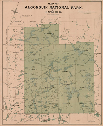
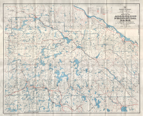
1893 Map of Algonquin National Park of Ontario
There are two versions of this map, The Archives of Ontario version and the Department of Lands & Forests version. Both can be downloaded from the links below:
There are two versions of this map, The Archives of Ontario version and the Department of Lands & Forests version. Both can be downloaded from the links below:
Archives of Ontario
Prepared to accompany Report of Park Commissioners to the Honourable A.S. Hardy, Commissioner of
Crown Lands - 1893
Prepared to accompany Report of Park Commissioners to the Honourable A.S. Hardy, Commissioner of
Crown Lands - 1893
File size - 1.5MB
File size - 2.5MB
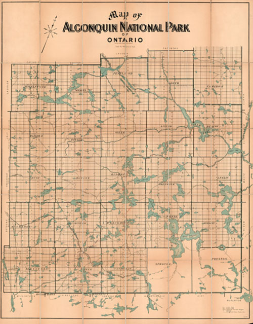
File size - 27MB
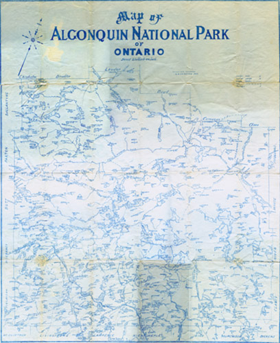
1908 Dr. Bell Algonquin Map
Map provided by Bruce Sutton, scanned by Mark Rubino and edited by Jeffrey McMurtrie.
Map provided by Bruce Sutton, scanned by Mark Rubino and edited by Jeffrey McMurtrie.
File size - 18MB
File size - 27.5MB

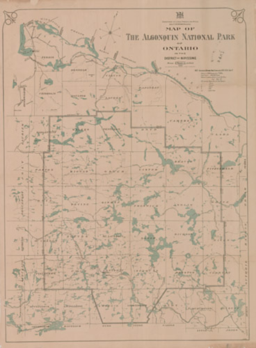
1914 Dept. Lands, Forests and Mines Algonquin Map
Map provided and scanned by Mark Bagu.
Map provided and scanned by Mark Bagu.
File size - 25MB
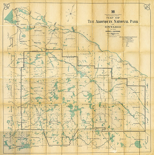
1919 Dept. Lands, Forests and Mines Algonquin Map
Map Provided and Scanned by Diana McElroy, Edited by Jeffrey McMurtrie
Map Provided and Scanned by Diana McElroy, Edited by Jeffrey McMurtrie
File size - 47MB
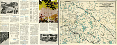
1922 CNR Algonquin Park Map
This map produced by Canadian National Railways(CNR) in 1922 included a travel guide located on the reverse side of the map. Both maps - Front & Back (Travel Guide) are available for download below:
Map Provided by Jeffrey McMurtrie and scanned by Mark Rubino.
This map produced by Canadian National Railways(CNR) in 1922 included a travel guide located on the reverse side of the map. Both maps - Front & Back (Travel Guide) are available for download below:
Map Provided by Jeffrey McMurtrie and scanned by Mark Rubino.
Map (Front)
File size - 28MB
Travel Guide (Back)
File size - 38MB

1925 Arthur Brown Algonquin Map
Scanned by Jeffrey McMurtrie.
Scanned by Jeffrey McMurtrie.
File size - 14MB
File size - 34MB

1946 Algonquin Park Area Map
Chief Geographer's Office,
Surveys and Engineering Division 1946
Map Provided by Bruce Sutton. Scanned and edited by Mark Rubino.
Chief Geographer's Office,
Surveys and Engineering Division 1946
Map Provided by Bruce Sutton. Scanned and edited by Mark Rubino.
File size - 9.5MB
1958 Algonquin Park Area Map
Dept of Lands and Forests Map 47a
Map provided, scanned and edited by
Jeffrey McMurtrie.
Dept of Lands and Forests Map 47a
Map provided, scanned and edited by
Jeffrey McMurtrie.
File size - 21MB
Enter the name for this tabbed section: Videos
Over the years I have accumulated many hours of video from my travels in Algonquin Park. Below are a few examples of video that I’ve put together and uploaded to my youtube channel.
Ragged Lake - Nov. 2015
This video depicts a snowy canoe camping trip to Ragged Lake in late November in 2015. The video was shot on an iPhone5 which is terrible in cold weather as the battery drains quickly. We were there for four days and didn’t see or hear another soul. This is exactly the kind of solitude we we’re looking for.
This video depicts a snowy canoe camping trip to Ragged Lake in late November in 2015. The video was shot on an iPhone5 which is terrible in cold weather as the battery drains quickly. We were there for four days and didn’t see or hear another soul. This is exactly the kind of solitude we we’re looking for.
Snowshoe to Longspur Lake
A short video of a recon trek to Longspur Lake shot in January 2014, near highway#60. I was scouting a sled-hauling route for an upcoming winter trip at the time.
Highway conditions were poor at times with snow-squalls being the weather of the day. I spent 7 hours in The Park that day and almost 8 hours driving to and from The Park!
Clips from Mizzy Lake Trail
A short video depicting a snowshoe thru Mizzy Lake Trail. in January 2016.
I do not recommend snowshoeing the entire length of the loop. Especially if you have to break trail - The loop is 11km long. For a report on the trip complete with a few photos, check out my blog posting here.
A short video depicting a snowshoe thru Mizzy Lake Trail. in January 2016.
I do not recommend snowshoeing the entire length of the loop. Especially if you have to break trail - The loop is 11km long. For a report on the trip complete with a few photos, check out my blog posting here.
White Partridge Express
This is nearly a 10 minute video of a trip to Algonquin Park’s east side, shot back in May of 2006. The rare and unique mode of transport to our campsite was via a horse-drawn wagon. Without our horse-drawn wagon, getting to White Partridge Lake from the nearest canoe route access point would’ve taken two days over several rough portages and many lakes.
This is nearly a 10 minute video of a trip to Algonquin Park’s east side, shot back in May of 2006. The rare and unique mode of transport to our campsite was via a horse-drawn wagon. Without our horse-drawn wagon, getting to White Partridge Lake from the nearest canoe route access point would’ve taken two days over several rough portages and many lakes.
Algonquin Park Man
In August 2008, "Bo Knows" performed an extended version of his Algonquin Park version of Johnny Cash's song, "I've been everywhere man". The video was shot on location in Algonquin Park on Kingscote Lake. The names of many lakes and rivers are depicted in the song. Have you been to all the ones Bo has visited? Watch the video to find out!
In August 2008, "Bo Knows" performed an extended version of his Algonquin Park version of Johnny Cash's song, "I've been everywhere man". The video was shot on location in Algonquin Park on Kingscote Lake. The names of many lakes and rivers are depicted in the song. Have you been to all the ones Bo has visited? Watch the video to find out!
Byers Lake Time Lapse
A time-lapse video I took while camping on Byers Lake in Algonquin Park’s south end in the month of June. The video contains copyrighted music authored under the creative commons license.
This was my first time using a go pro camera and its time-lapse function. Was fun to try out - Keep your eyes peeled for the snapping turtle.
Enter the name for this tabbed section: Wallpapers
Wallpapers to maintain your sanity while away from The Park. Below are a collection of some of my favourite locations through-out Algonquin Park. Wallpapers are now available in 4k resolution. All wallpapers have an aspect ratio of 16x9. Click on the download button of your choice. Enjoy.
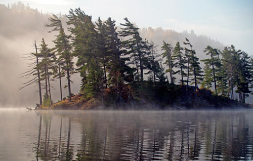
Spruce Bog frozen in February’s embrace
16:10 Aspect Ratio
1920 x 1200
1920 x 1200
16:9 Aspect Ratio
1920 x 1080
1920 x 1080

October afternoon on Mcintosh Lake
During an ambitious day-trip to McIntosh Lake (From Tom Thomson Lake), we encountered rare Indian summer conditions resulting in a glorious paddle.

September morning on Little Drummer Lake
16:10 Aspect Ratio
1920 x 1200
1920 x 1200
16:9 Aspect Ratio
1920 x 1080
1920 x 1080
Tom Thomson Lake
16:10 Aspect Ratio
1920 x 1200
1920 x 1200
16:9 Aspect Ratio
1920 x 1080
1920 x 1080
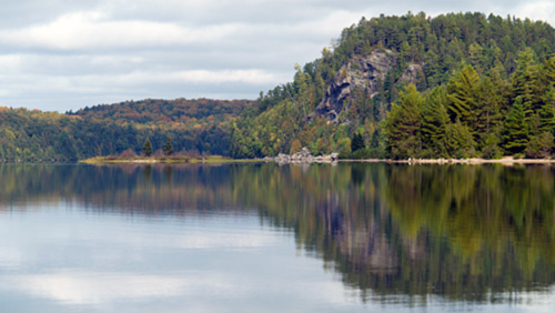
Cliffs of Hogan Lake
16:10 Aspect Ratio
1920 x 1200
1920 x 1200
16:9 Aspect Ratio
1920 x 1080
1920 x 1080

Hoodlum Falls - Mink Creek
16:10 Aspect Ratio
1920 x 1200
1920 x 1200
16:9 Aspect Ratio
1920 x 1080
1920 x 1080

Sunrise over Lake of Two Rivers [LoTR]
16:10 Aspect Ratio
1920 x 1200
1920 x 1200
16:9 Aspect Ratio
1920 x 1080
1920 x 1080
